
NASA’s Tropospheric Emissions: Monitoring of Pollution (TEMPO) mission, launched in 2023, has completed its initial 20-month prime mission. Due to the quality of its measurements, the mission has been extended through at least September 2026. TEMPO is NASA’s first mission to use a spectrometer to gather hourly air quality data continuously over North America during daytime, providing detailed insights down to a few square miles.
Laura Judd, a research physical scientist and TEMPO science team member at NASA’s Langley Research Center, noted, “NASA satellites have a long history of missions lasting well beyond the primary mission timeline. While TEMPO has completed its primary mission, the life for TEMPO is far from over. It is a big jump going from once-daily images prior to this mission to hourly data. We are continually learning how to use this data to interpret how emissions change over time and how to track anomalous events, such as smoggy days in cities or the transport of wildfire smoke.”
TEMPO measures nitrogen dioxide (NO2) and formaldehyde (HCHO) to derive the presence of near-surface ozone. For instance, on August 2, 2024, TEMPO observed high ozone levels over Houston, with NO2 building up over the city and the Houston Ship Channel, and formaldehyde levels peaking in the early afternoon. Formaldehyde is largely formed through the oxidation of hydrocarbons, an ingredient in ozone production, often emitted by petrochemical facilities.
TEMPO detects trace gases associated with altered air quality from sources like smog, wildfire smoke, dust, vehicle traffic, and power plants. These gases include nitrogen dioxide, ozone, and formaldehyde in the troposphere.
Hazem Mahmoud, lead data scientist at NASA’s Atmospheric Science Data Center, stated, “A major breakthrough during the primary mission has been the successful test of data delivery in under three hours with the help of NASA’s Satellite Needs Working Group. This information empowers decision-makers and first responders to issue timely air quality warnings and help the public reduce outdoor exposure during times of higher pollution.”
TEMPO data is archived and freely distributed through the Atmospheric Science Data Center. Mahmoud added, “The TEMPO mission has set a groundbreaking record as the first mission to surpass two petabytes, or 2 million gigabytes, of data downloads within a single year. With over 800 unique users, the substantial demand for TEMPO’s data underscores its critical role and the immense value it provides to the scientific community and beyond.” Data users primarily include air quality forecasters, atmospheric scientists, and health researchers.
An example of TEMPO’s utility occurred on April 14, when strong winds caused a dust storm in the U.S. central plains and fueled grassland fires in Oklahoma. TEMPO tracked NO2 plumes from the fires hourly. Additionally, the ultraviolet (UV) aerosol index indicated particulates like dust and smoke. On May 5, TEMPO measured NO2 emissions over the Twin Cities during morning rush hour, noting increases driven by agricultural soil emissions in the Red River Valley.
The TEMPO mission is a collaboration between NASA and the Smithsonian Astrophysical Observatory, with the latter’s Center for Astrophysics Harvard & Smithsonian overseeing daily operations and data product generation.
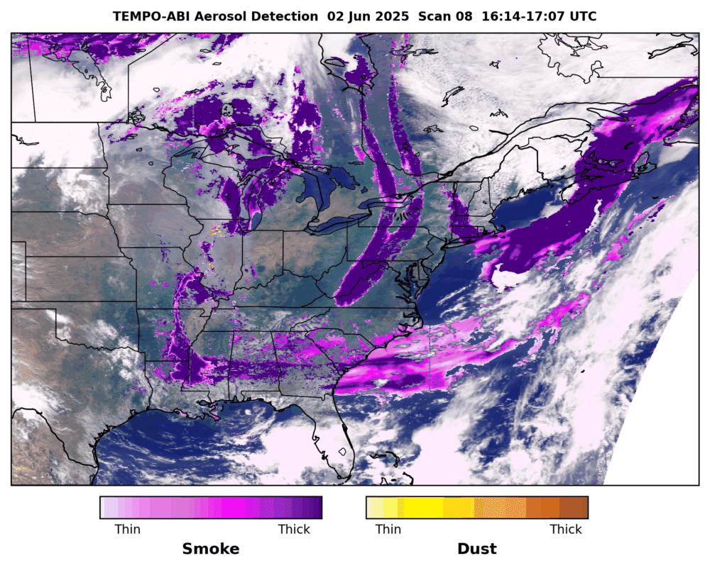
Collaborations with agencies like the National Oceanic and Atmospheric Administration (NOAA) are expanding TEMPO datasets. NOAA is deriving aerosol products to distinguish between smoke and dust particles and provide insights into their altitude and concentration.
Xiong Liu, TEMPO’s principal investigator at the Center for Astrophysics Harvard & Smithsonian, said, “These datasets are being used to inform the public of rush-hour pollution, air quality alerts, and the movement of smoke from forest fires. The library will soon grow with the important addition of aerosol products. Users will be able to use these expanded TEMPO products for air quality monitoring, improving forecast models, deriving pollutant amounts in emissions and many other science applications.”
Judd further commented, “The TEMPO data validation has truly been a community effort with over 20 agencies at the federal and international level, as well as a community of over 200 scientists at research and academic institutions. I look forward to seeing how TEMPO data will help close knowledge gaps about the timing, sources, and evolution of air pollution from this unprecedented space-based view.”
An agency review is scheduled for the fall to assess TEMPO’s achievements, extended mission goals, and identify lessons for future missions.
TEMPO is part of NASA’s Earth Venture Instrument program and forms a virtual constellation of Northern Hemisphere air quality monitors with South Korea’s Geostationary Environment Monitoring Spectrometer and ESA’s Sentinel-4 satellite. BAE Systems Inc., Space & Mission Systems (formerly Ball Aerospace) built TEMPO, which flies onboard the Intelsat 40e satellite built by Maxar Technologies. The TEMPO Instrument Operations Center and the Science Data Processing Center are operated by the Smithsonian Astrophysical Observatory, part of the Center for Astrophysics | Harvard & Smithsonian.